Showing posts with label USA - Alaska. Show all posts

Monday, May 11, 2026

Alaska - When the bear is bigger than the outhouse, RUN!

An Exaggeration Postcard from Alaska

When the bear is bigger than the outhouse, RUN!

This unused postcard is from 2016.

Friday, August 16, 2019

Alaska - Juneau, Mendenhall Glacier, Dear Doctor Postcard

Close to Juneau, Capital City of Alaska, is famed Mendenhall Glacier and equally scenic Auke Lake.

Dear Doctor:
Clinicians in Alaska, newest State in the Union, have long been acquainted with PENTOTHAL.  Here as elsewhere, it is used both as a primary and a supplementary agent.  25 years of use and the exhaustive published articles, now numbering over 3000, provide an unsurpassed clinical background

Abbott

Pentothal Sodium
(Thiopental Sodium for Injection, Abbott)

This advertising postcard was postmarked in 1959.

- - - - - - -

Alaska was admitted as the 49th state of the U.S. on January 3, 1959.  This postcard was postmarked in January 15, 1959. 

Friday, May 19, 2017

Alaska - Combat Fishing

Alaska
Combat Fishing

Photo by Grant Klotz

The sender writes:

I LOVED fishing with you in Alaska!  (Please don't EVER forget that on Wednesday, I caught my limit of 3 sockeye salmon before you even caught your 2nd one).  yes yes yes yes!
Love you :D

This postcard is from 2016.

- - - - - - -

I found this online...

Rules for Combat Fishing:

- Don’t take someone else’s spot

- When you hook a salmon, yell “fish on!” If someone near you yells this, take your line out of the water.

- If someone else has a fish and your lines become tangled, cut your line.

- Wear protective glasses to protect your eyes from flying hooks and sinkers.

Wednesday, April 12, 2017

Alaska - Denali, Harper Lodge

Harper Lodge
at Denali

The sender writes:
Snow is on all the mountains up here but we have lucked out on the weather so far.  We toured this park yesterday and saw caribou, grizzly bear, moose and sheep.  We also saw a new bird.  We will take the train ride of 8 hours next to Anchorage and then fly out on Tuesday.  The temp has been in the 20's and it doesn't warm up much.
1989

- - - - - - -

I think this lodge is now the Denali Princess Wilderness Lodge.
However I did find out that when it was the Harper Lodge, it was named after Walter Harper. . . .

At the age of 21, Harper became the first climber to reach the 20,320-foot summit of Mt. McKinley, (Now called Mout Denali),   the highest peak in North America.

The history-making moment happened on June 7, 1913. 

Sunday, August 7, 2016

Alaska - Seward, 1968

Seward, Alaska, on the Kenai Peninsula is the southern terminus of the Alaska railroad and one of the stops in the Western Alaska Marine Highway System.  This picture shows Main Street, rebuilt after the 1964 tidal wave.

Color Photo by Reggie Hibshman
Color by Mike Roberts
1968

- - - - - - -

The 1964 Alaskan earthquake, also known as the Great Alaskan earthquake and Good Friday earthquake, occurred at 5:36 P.M. AST on Good Friday, March 27.  Across south-central Alaska, ground fissures, collapsing structures, and tsunamis resulting from the earthquake caused about 139 deaths.

Lasting four minutes and thirty-eight seconds, the magnitude 9.2 megathrust earthquake was the most powerful recorded in North American history, and the second most powerful recorded in world history. 

Alaska - Native Whaling Boat

Alaska

Native Whaling Boat
Inupiaq subsistence whalers paddle their umiak, or bearded seal skin boat, to find passing bowhead whales traveling though the open lead, during spring whaling season, Chukchi Sea, offshore from Barrow, Arctic coast of Alaska.

Photo: Steven J. Kazlowski
2016

- - - - - - -

The IƱupiat (or Inupiaq) are an Inuit, Alaska Native people, whose traditional territory spans Norton Sound on the Bering Sea to the Canada–United States border.  (The old word for Inupiat is Eskimo.)

Barrow is a city that is located above the Arctic Circle in Northern Alaska.

Alaska - Mount Healy in Mount McKinley (Denali) National Park

Mount McKinley National Park, Alaska
Sunset on Mt. Healy - 5,716 Feet,
As views from the Park Hotel

Photo by W. Alan Cole.
1967

The sender writes:
As you can see, the sunsets are brilliant in color up here.  Sometimes you can't get to sleep because in the summer it doesn't get dark until midnight.  I often think of you.   You would just love to be able to read until then.  The Eskimos and Indians are very interesting people.  They make lovely handicrafts.  

Thursday, December 18, 2014

Alaska - Ketchikan, Fogwoman Totempole

Ketchikan

Fogwoman - the most popular of all totempoles, stands watching over beautiful Totem Bight State Park, Ketchikan, Alaska.
1995

- - - - - - - - - - -

The legend of Fogwoman:
According to the native Tlinglit and Haida people, Raven wanted to marry Fogwoman. Her father made him promise to treat her well, which he did. To honor Raven, Fogwoman created the salmon in the rivers so he would have something good to fish for. Then Raven began treating Fogwoman badly and she slipped through his fingers like wisps of fog, taking all of the salmon with her. Later Fogwoman took pity on Raven and allowed the salmon to return once a year.

Friday, October 17, 2014

Alaska - Tracy Arm, Blue Ice Fjord

Tracy Arm, Alaska
Blue Ice Fjord

Images of Alaska
Located a the end of the Tracy Arm Fjord in Alaska, the Sawyer Glaciers are the sorce of this blue glacier ice.
2010

- - - - - - - - - - - - - - - - - - - - - - - - - - - -

Tracy Arm is a fjord in Alaska near Juneau. It is named after a Civil War general named Benjamin Franklin Tracy. It is located about 45 miles (72 km) south of Juneau. Tracy Arm-Fords Terror Wilderness was designated as a wilderness area by the United States Congress in 1980.

The Tracy Arm area covers 653,179 acres (2,643.32 km2).  During the summer, the fjord has considerable floating ice ranging from the size of a three-story building to hand-size pieces.

The twin Sawyer Glaciers, North Sawyer and South Sawyer, are located at the end of Tracy Arm. The wildlife in the area includes black and brown bears, deer, wolves, harbor seals, and a variety of birds, such as arctic terns and pigeon guillemots. 

Friday, July 11, 2014

Alaska - Mosquito as State Bird

Alaska State Bird
The Mosquito
(Skeeter horribilis)

The Great Alaskan Mosquito (State Bird).
One of the most feared species known to man.  In the summer they rule the skies in search of their prey.  No matter how hard you try to protect yourself, there is no escape from their treacherous assault.  It is believed several large children and two or three small horses have actually been carried off never to be seen again.

Thursday, July 10, 2014

Alaska - Skagway, White Pass & Yukon Route Railway

White Pass and Yukon Route Railway
Skagway, Alaska

The White Pass & Yukon Route train descends the narrow gauge track back to Skagway, Alaska.
2010

- - - - - - - - - - - - - - - - - - - - - - - - - - - - - -

The White Pass and Yukon Route is a Canadian and U.S. Class II narrow gauge railroad linking the port of Skagway, Alaska with Whitehorse, the capital of Yukon, Canada. An isolated system, it has no direct connection to any other railroad.

The line was born of the Klondike Gold Rush of 1897. The most popular route taken by prospectors to the gold fields in Dawson City was a treacherous route from the nearest port in Skagway or nearby Dyea, Alaska across the mountains to the Canadian border at the summit of the Chilkoot Pass or the White Pass. There, the prospectors would not be allowed across by the Canadian authorities unless they had a full ton of supplies with them, which for most required several trips up and down the passes before entry to Canada could be obtained. There was a need for a better transportation scheme than the pack horses used over the White Pass or people's backs over the Chilkoot Pass. This need generated numerous railroad schemes. In 1897, the Canadian government received 32 proposals for Yukon railroads, most of which were never realized, however construction started on this line in May 1898. 

Monday, June 23, 2014

Alaska - Mount McKinley - From: Scenic American Landscapes, USPS

Mount McKinley, Alaska

The highest mountain in North America has long been known by the Athabascan as "Denali, "the High One."  Its two summits loom across nearly 9,500 square miles of Denali National Park and Preserve.
- - -
From a set of 'Scenic American Landscapes" stamped postcards from the United States Postal Service (USPS).

the back reads:
Share the pristine beauty of America's national parks with this set of 20 stamped cards.  Ten different designs showcase spectacular photographs originally featured on 'Scenic American Landscapes' stamps.  Postage included, so mailing is easy - or save them as a unique collectible set.
2010  

Monday, April 7, 2014

Alaska - Anchorage Hilton Hotel with Fireworks

The Anchorage Hilton

591 Guest rooms, Panoramic views of the Chugach Mountains and Cook Inlet, Alaskan Jade front desk, Sports edition Bar, Berry Patch and Top of the World restaurants, athletic club with pool and jacuzzi, tour desk, business center, banquet and ballroom facilities.

- - -

There is no reason mentioned for the fireworks in the back. I see Christmas lights in the bottom left corner and inside the windows, so maybe they are to celebrate the New Year.

Friday, September 20, 2013

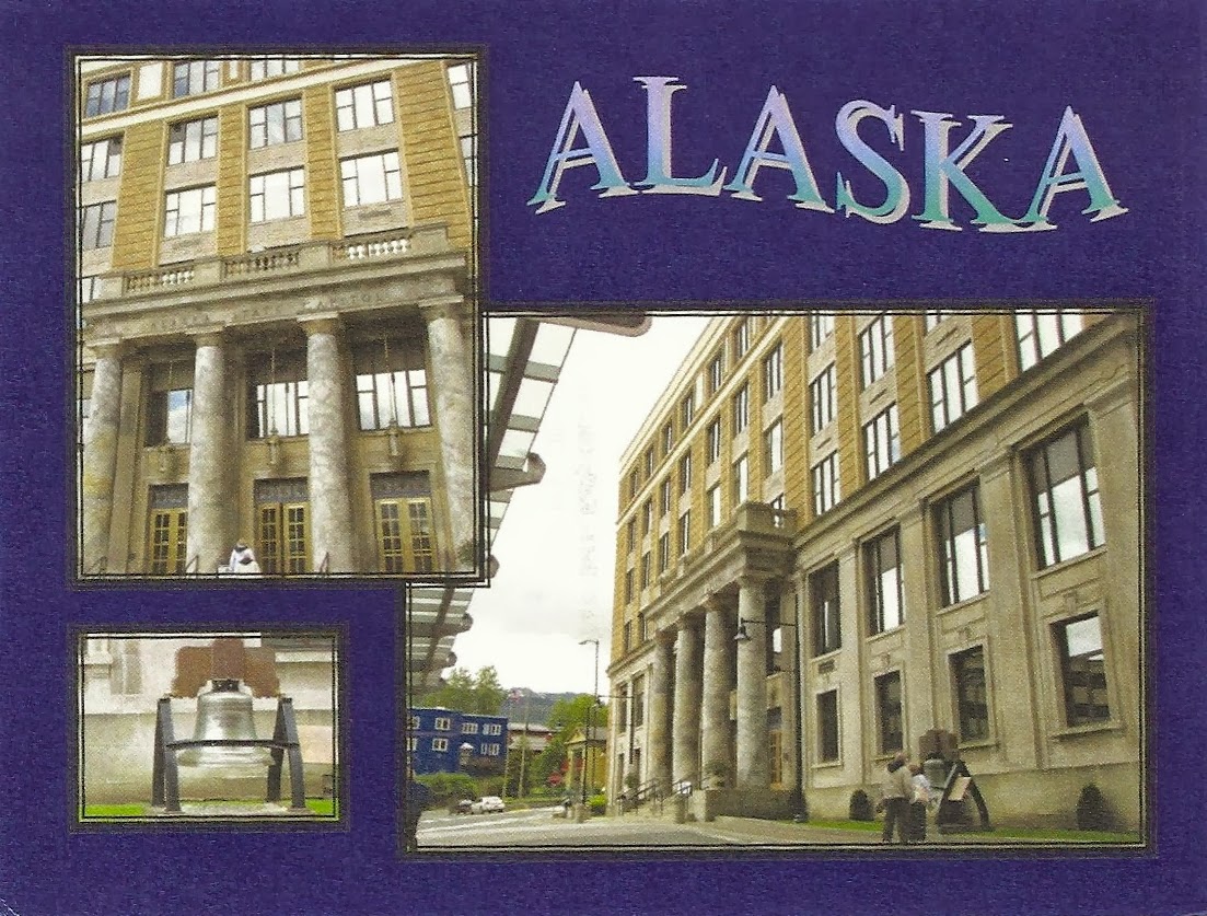
Alaska - Capitol Building


Alaska
In June of 2010 I had the privilege of visiting the capital of Alaska.  This was the first capital building I had ever seen in person so I was determined to take its picture and make an NPCW card of it.  we trekked from the cruise ship dock all the way through downtown and finally found the capital building in a crowded downtown area. The building was hard to photograph because it is so close to other buildings.  I hope you enjoy the card and have a very Happy National Postcard Week!

National Postcard Week
May 1-7, 2011

unused
Limited edition 115 of 120

Wednesday, May 22, 2013

Alaska - Map of Alaska, The Biggest State, US Map


Alaska is the BIGGEST State

- 19 Mountains over 14,000 ft.
- Highest point in North America, Mt McKinley 20,320 ft.
- More area than the 26 smallest states
- Purchased from Russia in 1867 for less than 2 cents an acre
- Longest days, 24 hours of daylight
- Longest nights, 24 hours of night
- More than 3 million lakes, larger than 25 acres
- 586,400 square miles
- 1/5 the land mass of the entire continental U.S.
- More than two times the size of Texas
- 29 active volcanoes, half the world's total
- More coastline than the lower 48 states, 33,000 miles
- More than 1/2 of the world's glaciers
- One glacier large than Switzerland

Discovered and colonized by the Russians in 1741 and purchased by the United States in 1867 for $7,200.600.  Alaska covers 586,400 square miles and its coastline exceeds the combined coastline of the entire U.S.

unused Curteich Postcard

Thursday, October 25, 2012

Alaska - Map of Oil Pipeline


Aaska's Oil Pipeline

48 inch pipe, 789 miles long will cross 3 mountain ranges and 70 rivers or streams
12 pumping stations
21 construction camps
3 years in construction

An estimated 10 billion barrels of crude oil

With central computer control at Valdez the pipeline is designated fro a maximum capacity of 2 million barrels of crude oil a day.

Oil was first discovered on Alaska's North Slope at Prudhoe Bay in March 1968.  Studies on a proposed pipeline started as early as August of the same year.  In September 1969 the State of Alaska held a Lease Sale of Prudhoe Bay land, a record 900 million dollars was paid to the State by those winning these leases.

There has been an unheralded number of engineering, ecological and permafrost studies along the pipeline route to assure safety of Alaska's wild-life and ecology.

Temperatures along the pipeline route vary from as much as 100 degrees F. in summer to more that 75 degrees below zero in winter.

The pipeline was three years in construction and cost over 8 billion dollars - the largest and most costly project ever undertaken by private industry.

- - - - - - -

The Trans-Alaska Pipeline System (TAPS) includes the trans-Alaska crude-oil pipeline, 11 pump stations, several hundred miles of feeder pipelines, and the Valdez Marine Terminal. TAPS is one of the world's largest pipeline systems. It is commonly called the Alaska pipeline, trans-Alaska pipeline, or Alyeska pipeline, (or the pipeline as referred to in Alaska), but those terms technically apply only to the 800 miles (1,287 km) of the pipeline with the diameter of 48 inches (122 cm) that conveys oil from Prudhoe Bay, to Valdez, Alaska. The crude oil pipeline is privately owned by the Alyeska Pipeline Service Company.

The pipeline was built between 1974 and 1977 after the 1973 oil crisis caused a sharp rise in oil prices in the United States. This rise made exploration of the Prudhoe Bay oil field economically feasible. The project attracted tens of thousands of workers to Alaska, causing a boomtown atmosphere in Valdez, Fairbanks, and Anchorage.

The first barrel of oil traveled through the pipeline in 1977, and full-scale production began by the end of the year. Several notable incidents of oil leakage have occurred since, including those caused by sabotage, maintenance failures, and gunshot holes. As of 2010, the pipeline has shipped almost 16 billion barrels (2.5×10⁹ m3) of oil.

Alaska - Great Trans-Alaska Pipeline


The Great Trans-Alaska Pipeline

The 800-mile, 48" Pipeline runs from Prudhoe Bay to Valdez.  Pictures left is, top center, Visitor Information Cabin near Fox; Upper left, The Last Cat train carrying supplies past Anaktuvuk Pass to Prudhoe Bay; upper right, Alyeska Security Helicopters patrolling the pipeline; lower left, Burying the firs piece of pipe at Tonsina; lower right, The 150,000-ton tanker ARCO Juneau and the 265,000-ton tanker Northern Lion taking on oil at Valdez; lower center, Commemorative State at Valdez.
1995

- - - - - - -

The Trans-Alaska Pipeline System (TAPS) includes the trans-Alaska crude-oil pipeline, 11 pump stations, several hundred miles of feeder pipelines, and the Valdez Marine Terminal. TAPS is one of the world's largest pipeline systems. It is commonly called the Alaska pipeline, trans-Alaska pipeline, or Alyeska pipeline, (or the pipeline as referred to in Alaska), but those terms technically apply only to the 800 miles (1,287 km) of the pipeline with the diameter of 48 inches (122 cm) that conveys oil from Prudhoe Bay, to Valdez, Alaska. The crude oil pipeline is privately owned by the Alyeska Pipeline Service Company.

The pipeline was built between 1974 and 1977 after the 1973 oil crisis caused a sharp rise in oil prices in the United States. This rise made exploration of the Prudhoe Bay oil field economically feasible. The project attracted tens of thousands of workers to Alaska, causing a boomtown atmosphere in Valdez, Fairbanks, and Anchorage.

The first barrel of oil traveled through the pipeline in 1977, and full-scale production began by the end of the year. Several notable incidents of oil leakage have occurred since, including those caused by sabotage, maintenance failures, and gunshot holes. As of 2010, the pipeline has shipped almost 16 billion barrels (2.5×10⁹ m3) of oil.

Saturday, June 16, 2012

Alaska - Inside Passage, Glacier Bay National Park


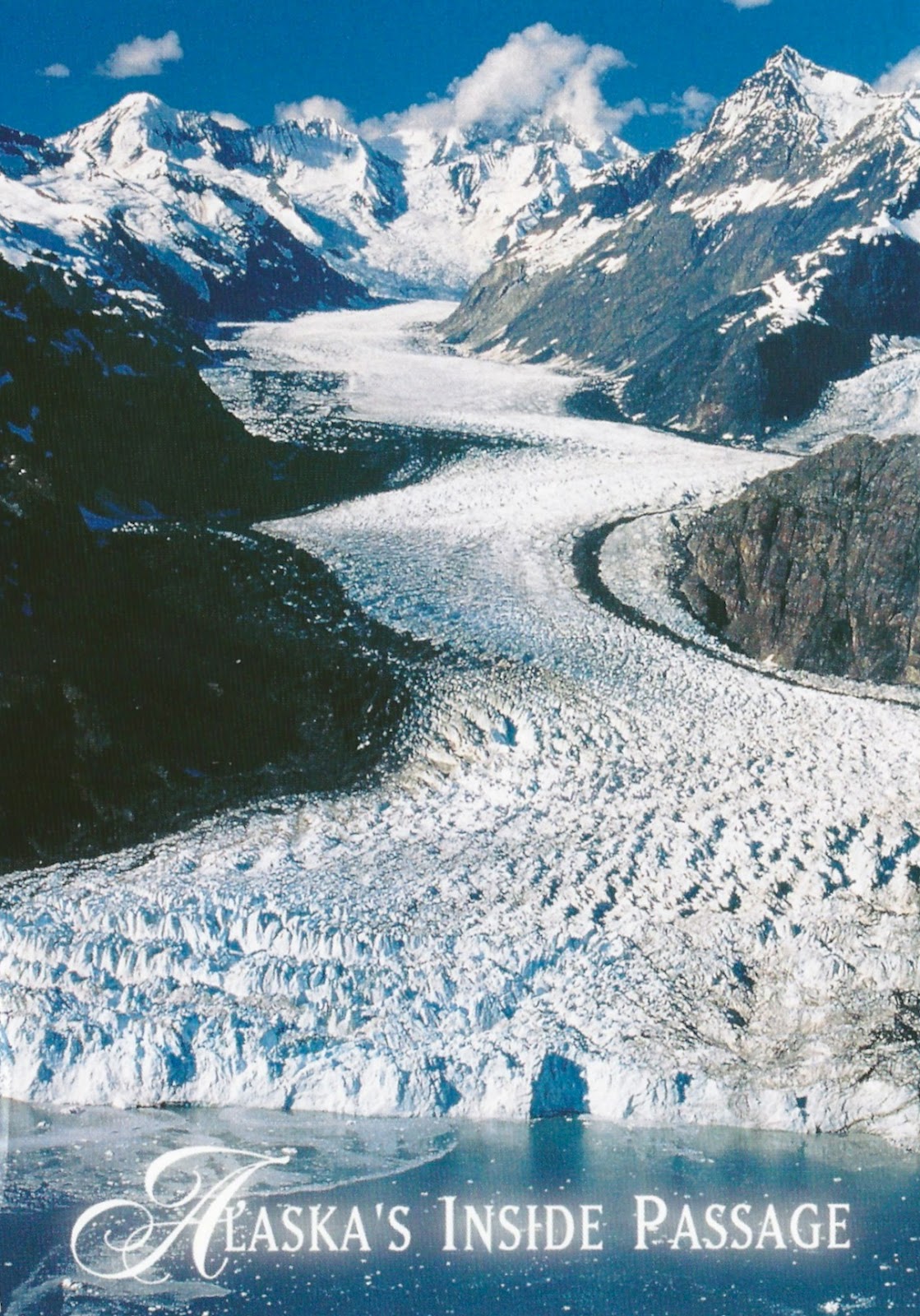
Alaska's Inside Passage
Aerial view of Margerie Glacier, Glacier Bay National Park, Alaska

Photo: John Hyde
2012

- - - - - - -

The Inside Passage is a coastal route for oceangoing vessels along a network of passages which weave through the islands on the Pacific coast of North America. The route extends from southeastern Alaska, in the United States, through western British Columbia, in Canada, to northwestern Washington state, in the United States. Ships using the route can avoid some of the bad weather in the open ocean and may visit some of the many isolated communities along the route. The Inside Passage is heavily travelled by cruise ships, freighters, tugs with tows, fishing craft and ships of the Alaska Marine Highway, BC Ferries, and Washington State Ferries systems.

Margerie Glacier is a 21-mile-long (34 km) tide water glacier in Glacier Bay.